Forest
Forest Management Services
Training
Remote Sensing Courses and Training
Evidence
Providing evidence and data for controlling purposes
Water
Water Body Mapping
Remote Sensing is the art of gathering information about our planet from space using satellites. This can be done for the densest urban regions as well as for the most remote regions on our planet without physically going there. Different kinds of satellites provide data for a wide range of applications. Some satellites can even map the Earth independent from daylight and cloud cover. Software tools help us to analyze satellite data and derive different kinds of information about the state of our planet, natural resources and manmade phenomena.
Services offered include the following.
Forest management products
Forests cover one third of the Earth’s land masses. They are the source for a renewable resource, which has the longest period of use by humans: Timber. Timber can be used for energy production, as building and construction material or as a base product for the production of other goods such as pulp and paper or chemical products. To guarantee future timber supply, forests require sustainable management practices. Sustainable forestry essentially relies on up to date information on forested areas, clear cuts, areas affected by forest fires and pests, and of course on the Timber Volumes (sometimes also called Growing Stock Volume (GSV) or Biomass). Such information is usually obtained through field work, which is time consuming and expensive especially for remote and hard to reach areas. This is where remote sensing can provide significant benefits with regard to time and resources when compared to traditional methods of Timber Volume estimation.
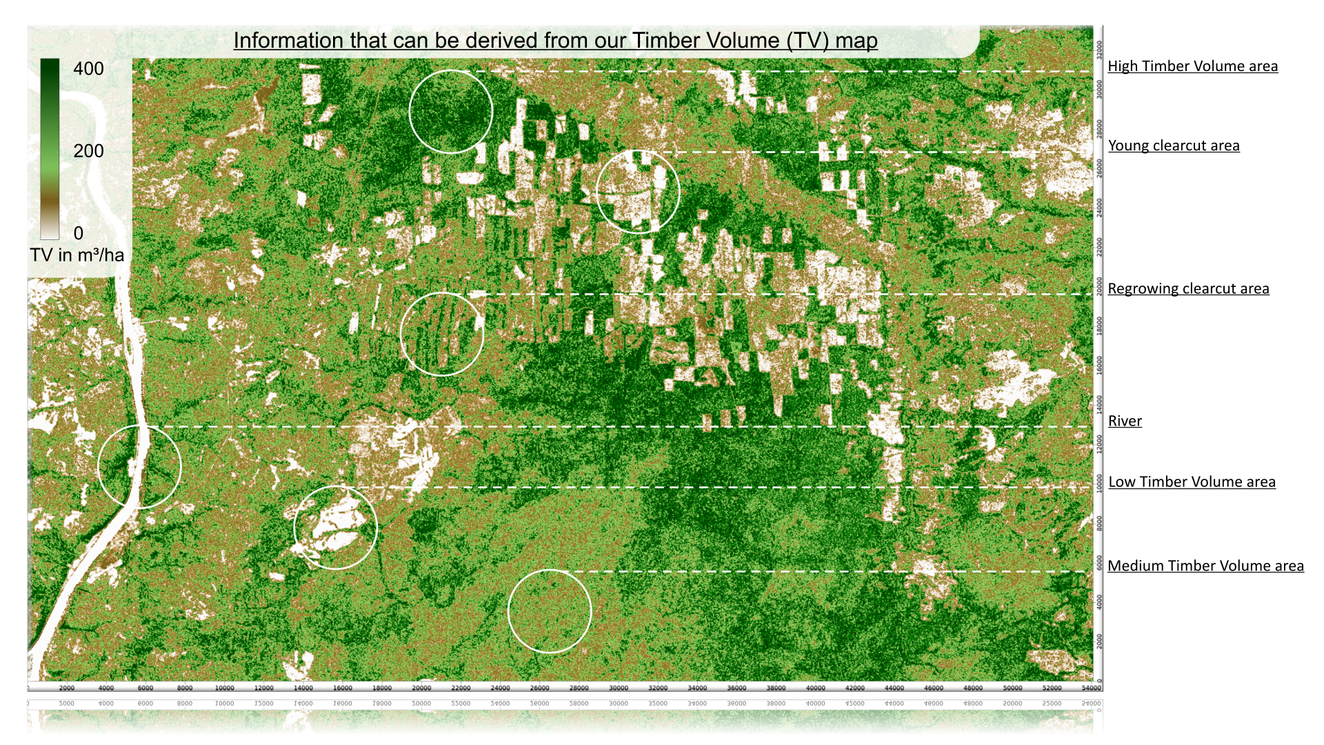
Radar remote sensing as a time saving and cost-effective remote sensing technology, which allows the derivation of such information on different space and time scales, independent from cloud cover and sunlight. Based on radar satellite data we generate digital maps showing forest parameters for further use in other IT environments such as GIS systems (see image Timber Volume image above).
Other examples of the Timber Volume maps we produce can be found in the Showcase area of this website.
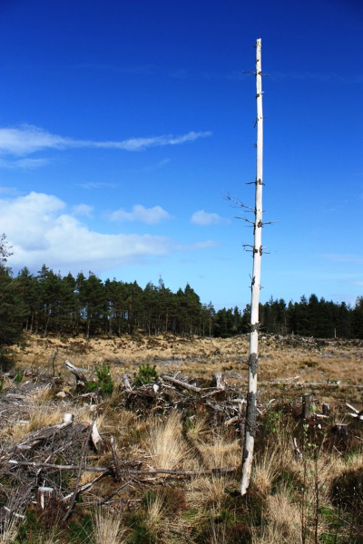
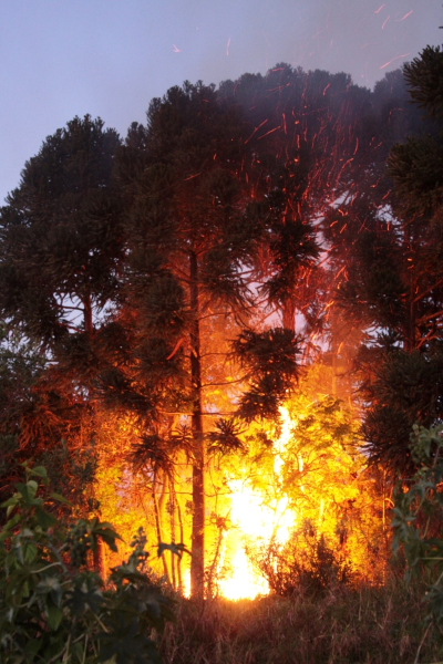
Below are some examples of a forest fire and clear cutting. Knowing how much damage your forest has taken due to the last fire, windthrow, other natural causes or even illegal logging enable you to calculate you losses and adjust your planning schedules.
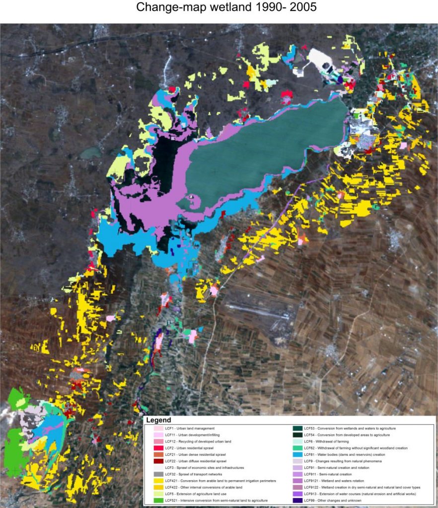
Providing evidence and data for controlling purposes
Human economic activities are often confronted with legal issues limiting undertakings to certain areas, periods or allowing withdrawal of natural resources only at limited rates and/or time periods.
Remotely sensed satellite data and images can be used to provide objective evidence of the state of an area at the Earth’s surface before, during and after activities affected by such legal issues as mentioned before.
To this end, we use GIS-Software to produce so called “change maps” in which the changes of the surface structures can be highlighted and used for evidential purposes.


Mapping of open water surfaces and inundation areas
Water surfaces and water bodies are no constant objects; usually the water surface level may change with the seasons. Man-made objects, buildings, technical infrastructure may be at danger when placed close to water bodies, rivers and streams. Urban growth may lead to the use of areas close to sea and lake shores or rivers and streams, which were not built-up in the past. Radar remote sensing with its unique sensitivity to water can help to identify the location of water bodies or to delineate shorelines. The formation of inundation areas may be the result of snow-melt or severe weather conditions. Usually such situations are characterized by dense cloud cover – here radar remote sensing, which can see through clouds, can help to map and monitor flooding.
Soil moisture mapping
Soil moisture plays an important role in farming. The availability of water in the soil limits plant growth and therefore has an important impact on crop yield and thus on market prices of agricultural products such as grain, potatoes, etc. Furthermore, information on soil moisture is important to precision farming, which helps to reduce costs by precisely controlling irrigation, fertilization and crop spraying.
Auch sind Bodenfeuchteinformationen im Rahmen des “Precision Farming” von großer Bedeutung, indem sie helfen, durch zielgenaue Steuerung von Bewässerung und Düngung Kosten zu reduzieren
Surface movements
Sometimes the ground on which we stand is not as solid as we may think. Different processes can lead to surface movements such as subsidence and surface uplift. Causes may be natural phenomena or human activities such as mining or groundwater withdrawals. Capturing these changes using classical surveying techniques is costly and to time consuming. Surface changes can also be made visible using specialized radar satellite technology. By using the right tools combined with our ability to interpret satellite data we are able to generate maps indicating places and rates of such surface movements. These kind of maps can show the movement of glaciers, volcanos, mountains and even elevation changes in cities (e.g. due to subway line construction) over a certain period.
Digital elevation models
Detailed knowledge of the three-dimensional shape of the Earth’s surface is of great interest for many applications. Planning and building infrastructure especially in previously undeveloped areas for which there are no or outdated topographic maps or maps at insufficient spatial scales requires information on the shape of the Earth’s surface. Other applications can be found in seismic route planning in preparation of prospection activities for future oil or gas production.
The following image (below) shows what a digital elevation model can look like. In this example, we show an area, which ranges from 0 meters up to 300 meters above ground level.
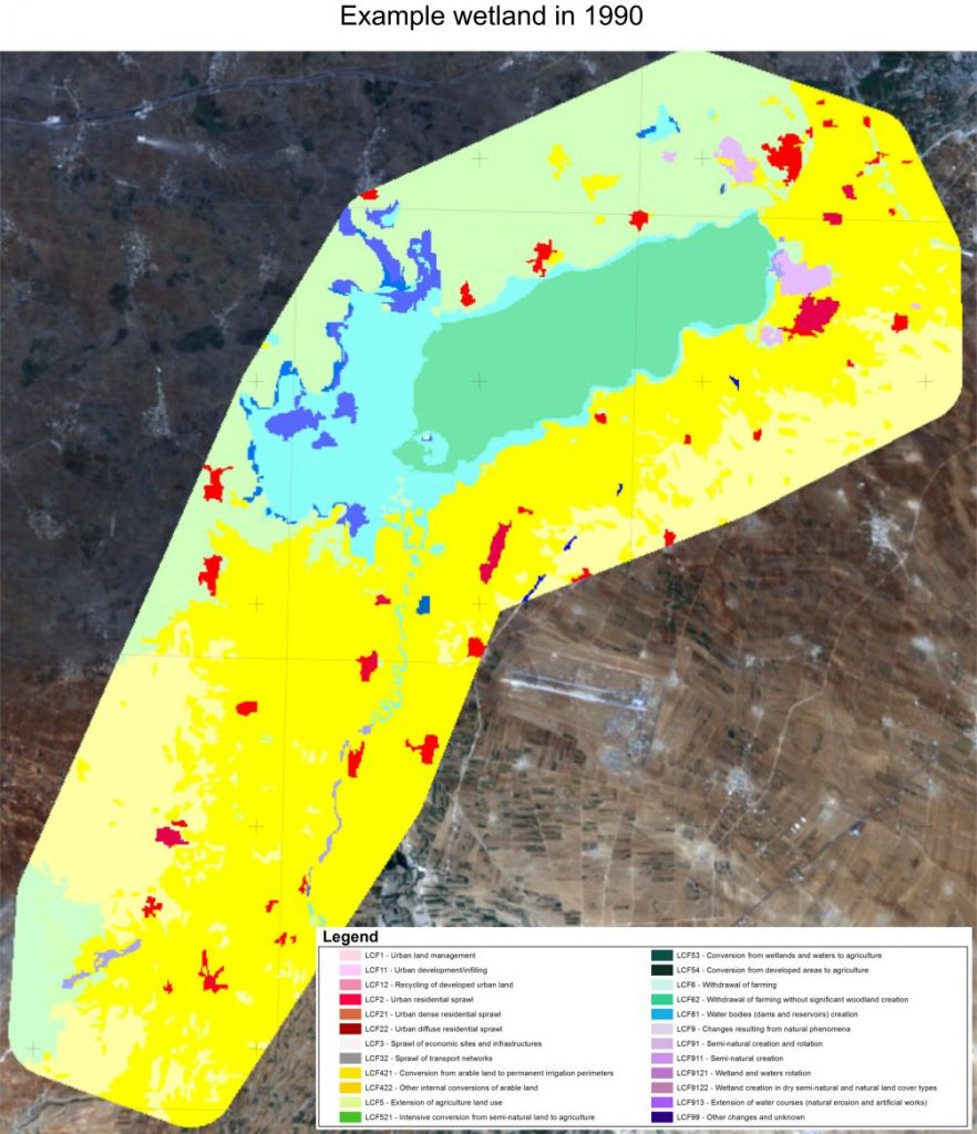
Land cover and land usage maps
Humans alter the appearance of the Earth’s surface with their activities by extending settlements, building new roads, forestry related activities or changing agricultural practices just to name a few. The classical way of map-making often cannot keep up with the rapid changes as it involves time consuming surveying campaigns and manual fieldwork. Satellites can capture land cover patterns within a fraction of a second. After processing the satellite information, we are able to identify the kind of surface types on that particular piece of land. From there we can convert such satellite images into digital and classical printed land cover maps. These maps allow you to get an overview of the land cover types, which then e.g. allows for city or landscape planning, disaster area evaluation and changes in land usage over longer periods (e.g. growth or decline of a city or forest).
As shown in a previous service (Providing evidence etc.) the pictures below show land usage and land cover maps which are useful for analyzing the changes in the landscape as well as knowing what a piece of land is being used for.
Data mosaics and satellite maps
There is a multitude of satellites using different imaging techniques delivering image data of the Earth’s surface with each image covering a limited area. A number of images can be used to form a data mosaic to cover larger areas. For this task, the image data require some kind of processing as they may have been acquired under slightly different environmental conditions which may lead to visible image borders. If the image data undergo further treatment regarding the geo-location of the image data sets, large area satellite maps can be generated.
Processing of satellite image data (optical and radar)
Satellite data come in various formats and require a number of processing steps before they can be used for information retrieval. We have the experience and the right software tools to read these data and convert them to file formats that can be easily used within common software environments.
GIS Services
Geographic Information Systems (GIS) are information systems that allow storing, editing, analyzing and graphical representation of geographical data – data of any kind that are connected to a geographical location, e.g. an address or a pair of coordinates. GIS-Software facilitates the link between remotely sensed information (such as land cover) and other statistical or measurement data. All the information is stored in data bases which allow fast and easy access to the data.
Services offered include the following:
Data collection, digitalization and evaluation
Once all necessary data are stored in a GIS database, we analyze the data to your specifications. This comprises such issues like measurements of distances/areas/volumes, spatial and thematic data intersections, network routing, data buffering as well as the analysis of digital elevation models.
Set-up of GIS projects
GIS is ideally suited for handling data within all kinds of projects involving remote sensing image data and/or geographical data.
Consulting
The growing trend towards specialized jobs and knowledge makes it difficult to complete projects without assistance of outside consultants. The explosion of knowledge that the internet has helped facilitate is a real advantage compared with the ages before.
By offering our experience and expertise with regard to earth observation projects, we are able to add value to your projects. We gather, process, analyze, map and visualize all information that can be derived from your satellite and aerial measurement data (optical and radar spectral bands).
We possess advanced knowledge and experience in terms of radar remote sensing (X, C, L-band) and visualizing the information derived from decoding the backscatter (reflecting waves) measured by satellites and aerial platforms. Only a few companies in the world have mastered the complicated decoding and visualization process of radar remote sensing data. Our advantage is our close cooperation with the world- renowned earth observation department of the Friedrich-Schiller-University in Jena (DE), which keeps us up to date on all new theories, models and algorithms.
The advantages of having us onboard are manifold and encompass, but are not limited to, the following:
- A competent brainstorming partner, who will assist in exploring the possibilities, limitations and potentials of using satellite and/or aerial earth observation measurements (remote sensing ) and GIS services in your projects
- A dedicated company, which will analyze what it can add to your project and will honestly step back if no value can be added
- An objective second opinion if you have doubts concerning the strategy, validity and other important aspects of your projects
- Access to expert knowledge with regard to the mapping and monitoring (change maps) of forests, urban areas, wetlands etc.
- A cost comparison between remote sensing and traditional data acquisition methods
- Advice on which data sets, models and methods will benefit your project the most
- A partner or sub-contractor for scientific research and development as well as for managing and processing large operational data sets